Wildfire Without Borders: Why We Need Early Warning Systems and Holistic Risk Frameworks
Manju Smriti, Alqamah Sayeed
7/24/20255 min read
"Heraclitus' theory of change envisioned that all material things, whether solid, liquid, or gas, are like flames: they are all transformations of fire. They are not things, but processes, transformations, and flows of becoming." Yet in these flows, Heraclitus saw not chaos but a law, a reason, a wisdom. Every process, especially fire, unfolds according to a natural order, a "measure" intrinsic to the world."
Today, what was once nature's measured order has been driven into crisis. Shifting climate patterns, altered land use, and expanding human settlements have amplified the scale and cost of wildfires, transforming them into an escalating threat — not only to local lives and livelihoods, but to entire economies, ecosystems, and the stability of the global climate system.
The July 2025 Canadian Wildfires: Assessing Systemic and Transboundary Risks
The Canadian wildfires of July 2025 starkly revealed the compounding risks of climate-driven fire events. Over the span of a single week, more than 2,900 fires scorched western Canada, consuming over 4.6 million hectares of forest, peatland, and wildland—one of the most intense fire seasons on record.
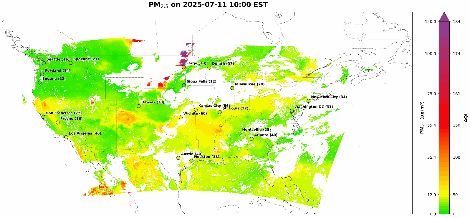
Cities across Saskatchewan and Manitoba province in Canada were enveloped in thick smoke. In the U.S. state of North Dakota, air quality monitors recorded PM2.5 levels exceeding 300 µg/m³ in Fargo, classified as

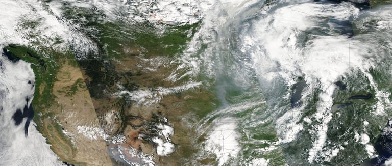
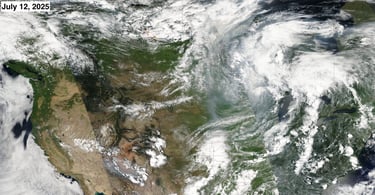
hazardous by U.S. EPA standards. The GOES-R satellite tracked dense plumes sweeping southeast into the U.S. Midwest, while VIIRS thermal anomaly data identified active ignition zones with high precision.
Satellite-derived aerosol optical depth (AOD) data from GOES-R, used to estimate surface-level PM2.5 concentrations, revealed a dynamic progression of smoke across western and central North America. From July 8 to 10, wildfire smoke from British Columbia and Alberta was gradually transported eastward under a broad high-pressure ridge, with light northwesterly winds enabling fine particulate matter to accumulate and drift into Saskatchewan, where PM2.5 levels reached 75 µg/m³, prompting alerts in Saskatoon and Regina.
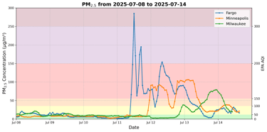
By July 10, concentrations surpassed 100 µg/m³ near the Saskatchewan–Manitoba border, prompting emergency response measures. Between July 11 and 12, a surface low-pressure system formed over southern Manitoba, strengthening westerly flow and rapidly transporting smoke into Ontario and the U.S. Midwest. Fargo experienced a dramatic spike in PM2.5 near 300 µg/m³, while Minneapolis exceeded 150 µg/m³, both registering in the “Very Unhealthy” to “Hazardous” range. Milwaukee experienced a more gradual exposure, with elevated concentrations lasting through July 14.
The event peaked on July 12, as widespread PM2.5 concentrations above 100 µg/m³ blanketed southern Manitoba, eastern North Dakota, and western Minnesota. A cold front, which moved through on July 13–14, brought cooler air and increased atmospheric mixing, helping to disperse residual smoke layers. However, elevated pollution levels persisted in localized areas, prompting continued health advisories.
These observations demonstrate the critical role of satellite-based systems in capturing the spatiotemporal dynamics of wildfire smoke. Tools like GOES-R and VIIRS, when combined with ground-based air quality monitoring, provide essential early-warning capabilities for emergency response, public health planning, and transboundary environmental coordination.
Harnessing Earth Observation: Closing the Gaps in Wildfire Detection and Response
Wildfires are no longer isolated ecological events—they are multifaceted crises that destabilize public health systems, disrupt agriculture, and undermine economic resilience. Among the most insidious impacts is wildfire smoke, which releases vast quantities of fine particulate matter (PM2.5) that can travel hundreds of kilometers beyond the burn area.
Unlike the immediate destruction caused by wildfires, the health effects of wildfire smoke unfold gradually and accumulate over time. PM2.5 particles penetrate deeply into the respiratory and cardiovascular systems, particularly among vulnerable groups, including children, older adults, and individuals with pre-existing conditions. While the World Health Organization recommends a 24-hour PM2.5 limit of just 15 µg/m³, wildfire smoke events often drive concentrations well beyond 100 µg/m³. At these levels, even short-term exposure—over 24 hours or less—has been linked to increased hospitalizations, emergency visits, and mortality. Health risks escalate significantly with each 10 µg/m³ increase beyond ~35 µg/m³, with cumulative effects intensifying over prolonged exposure.
Despite progress in air quality monitoring, the greatest opportunity for mitigating wildfire impacts lies upstream—at the point of detection. Satellite-based systems such as the Canadian Wildland Fire Information System (CWFIS) and the U.S. National Interagency Fire Center (NIFC) already utilize instruments like MODIS and VIIRS to detect thermal anomalies. These tools are essential for alerting and situational awareness, but their effectiveness is constrained by limitations in latency, temporal or spatial resolution, and real-time integration into emergency response systems.
High-frequency Earth observation assets such as GOES-R, TEMPO, and VIIRS are already operational in the context of North America and play vital roles in wildfire detection and air quality monitoring. However, they currently operate in separate observational domains, rather than as a fully integrated system. Fusing their capabilities—combining GOES-R’s rapid temporal updates, VIIRS’ high spatial resolution, and TEMPO’s atmospheric composition data—remains a critical next step in advancing early warning systems and coordinated disaster response. Together, they could offer more comprehensive coverage of fire ignition, thermal plume evolution, and pollutant transport in near-real time.
Yet early detection is only part of the solution. Strengthening smoke dispersion forecasting, integrating alerts into public health platforms, and improving cross-border data sharing are critical for preparedness. Coordinated action between agencies like CWFIS and NIFC, coupled with proactive landscape management (e.g., prescribed burns) and investment in community resilience, will determine how effectively nations can respond.
The earlier a hotspot is identified, the more time responders have to contain the fire, warn communities, and safeguard health systems. As climate-driven wildfires increase in frequency and intensity, robust satellite-based detection must evolve from a technical asset into a foundational pillar of climate adaptation, disaster risk reduction, and public health protection.
Rethinking Wildfire Governance: Toward a Holistic and Adaptive Framework
To confront climate-intensified wildfires, we must move beyond technological fixes toward adaptive, holistic governance. This means not only fusing satellite datasets into real-time, actionable intelligence but also embedding those insights within public health systems, local emergency protocols, land-use management, and community preparedness. It demands cross-sector and cross-border coordination as a default practice, not as an ad hoc response to a crisis.
Without this integration, we risk confusing surveillance with safety and detection with preparedness. Effective wildfire governance is not just a matter of monitoring heat or smoke; it is about building anticipatory capacities across institutions, creating feedback loops that link early warning to early action, and empowering communities as proactive agents, not passive recipients, of resilience strategies.
While fire is a natural phenomenon, catastrophe belongs to us, shaped by our governance, ethics, and institutional readiness. Meeting the challenge will require adaptive frameworks that can evolve with shifting risks, governance mechanisms that prioritize collaboration over silos, and a deep commitment to safeguard both people and ecosystems in an era of accelerating volatility. Only by reimagining wildfire governance as interconnected, adaptive, and human-centered can we meet the scale and speed of the challenge ahead.
Fire and Thermal Anomaly with Smoke Plumes -Source: NASA Worldview
Source: EPA monitoring stations
Contact US
+1 (205) 898 - 7997
msmriti@bridgerpf.org
8 The Green Ste B, Dover, DE 19901
Mon - Fri: 9:00am - 5:00pm
Connect for Change
Your insights and inquiries are vital to our mission of transforming research into impactful policy. Whether you're seeking collaboration or have questions about our initiatives, we invite you to reach out and be a part of the change.
© 2024. All rights reserved.